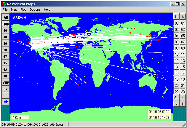
160 Spots as if they were all from the West Coast
Convolve Spotted Paths to Predict Propagation
160 Spots as if they were all from the West Coast
The multitude of paths reported by all of the spotters in the world has created the opportunity to predict propagation based on known openings at a given time and frequency between stations at similar latitudes later in the day. The Convolve as local prediction command in the Plot Menu of the Map Window has been designed to display these probable band openings.
In this case, convolve means that multiple points have been rolled together to one
line of longitude.
An example
In the Main Window, click the 24 button to display the last 24 hours of data in the History Window.
In the History Window, click on the
 Map Button to show all of the spots on the map. Select the
Mercator or Azimuthal Map as you wish. This will be more information than you can make sense of,
so choose one band. 10 Meters or 160 are the bands where this technique is most useful. Click on the
10 button. If the Band Buttons are not showing, select
Show Band Buttons in the
Options Menu.
Map Button to show all of the spots on the map. Select the
Mercator or Azimuthal Map as you wish. This will be more information than you can make sense of,
so choose one band. 10 Meters or 160 are the bands where this technique is most useful. Click on the
10 button. If the Band Buttons are not showing, select
Show Band Buttons in the
Options Menu.
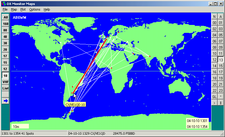
10 Meter Propagation around 1300z
Notice that F5BDB has spotted CX/VE1QD at 1329z. This path is highlighted in red. If there is not a large change in solar flux or a geomagnetic disturbance, it is reasonable to assume that the open path will follow the sun as the earth turns.
The Convolve plot, takes all of the spots from the map (in this case, an entire day) and rotates them to your longitude. The latitude is adjusted for changes in geomagnetic latitude. Because the magnetic north pole is not at the north pole, it is necessary to do a more complex calculation, but DX Monitor does this for you.
DX Monitor uses 82.3°N 113.4°W as the location of the magnetic north pole for the calculation of geomagnetic latitude based on estimates from Natural Resources Canada. The actual location of the pole can move as much as 80 km in 12 hours.
Spots which indicate paths, in either direction, from stations at a similar geomagnetic latitude to your location, are all plotted on the map as if they occurred from near you. The locations of the ends of the paths are based on the calculated equivalent geomagnetic latitudes adjusted for the rotation of the earth.
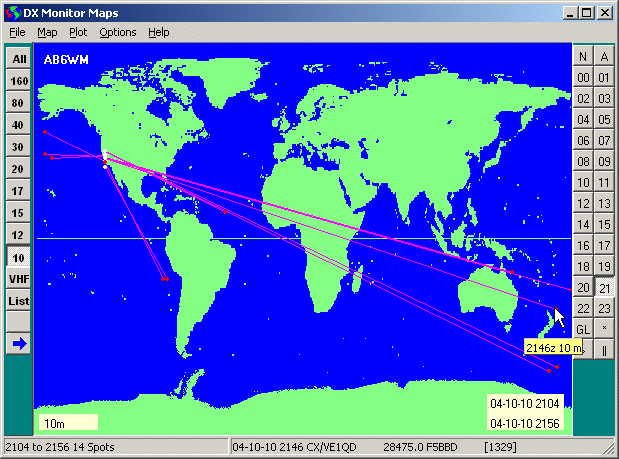
10 Meter Propagation predicted for 2100z
The open paths predicted for 2100 to 2200z have been selected by pressing the 21 button on the right.
At 2146z, the solar time on the west coast will be the same as it was in France at 1329z. The path opening noted earlier in the day is plotted on the map. The actual path is across the Pacific, of course. The Azimuthal Map is clearer when you are used to looking at the world from your own location, and I recommend using it most of the time.
Moving the mouse over the DX spot shows the predicted opening time and band in the floating window and the spot data in the panel at the bottom of the window. The time has been adjusted for the change in longitude. The original time is shown in brackets in the comment as [1329] for reference.
The prediction is that there will be an opening to New Zealand from the West Coast on
10 meters. Numerous other paths are also shown based on spots from various parts of the
world earlier in the day. Some of these openings are to areas with no stations, but
perhaps there is a Maritime Mobile in that area. Or perhaps a remote island with a rare
prefix is going to be on.
Caveats
This is an interesting new tool to experiment with. I look forward to hearing from someone who has bagged a new DXCC country, thanks to the convolution prediction.
The predictions will work best on days when there is little change in the solar flux or geomagnetic indexes as shown in the WWV Window. Propagation is also affected by whether there is land or water in the intervening path. Some locations, such as Asiatic Russia are not well defined when plotted because the prefixes cover very large areas. These paths may actually be somewhat different from what is shown on the map.
The comment may also be important. The program maps the paths between spotter and DX station, but the comment may say “Nothing heard here”! Pay attention.
There are never guarantees. This is one new tool to add to your toolbox for intelligent DXing.